Categories
News Redistricting

OC could gain clout in Sacramento

State Sen. Josh Newman uses an ice cream truck to promote his campaign to retake the 29th Senate District on Saturday, Feb. 15, 2020 in Anaheim. Newman’s 2022 prospects could be challenging if draft maps of new political boundaries are finalized in December. (Photo by Michael Fernandez, Contributing Photographer)By BROOKE STAGGS | bstaggs@scng.com | Orange County RegisterPUBLISHED: November 11, 2021 at 6:59 p.m. | UPDATED: November 12, 2021 at 8:48 a.m.

Orange County might gain one more voice in Sacramento.

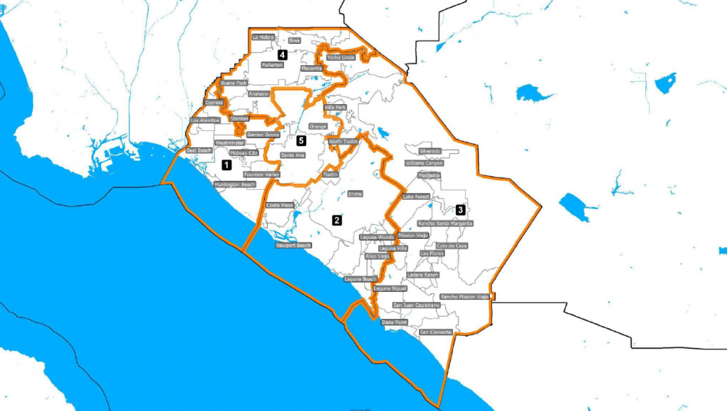
Draft maps of proposed new boundaries for state legislative districts, released late Wednesday by the California’s Citizens Redistricting Commission, suggest taking the county from seven to eight Assembly districts to balance out population changes found in the 2020 Census.

But if the proposed boundaries stick, several local incumbents could face tough choices, with some representatives drawn out of their current districts or into new ones that figure to be less favorable to their 2022 re-election.

So, while these maps could change significantly before final maps are due Dec. 27, they’re already causing heartburn for some politicians and their consultants.

“This is the quandary for any legislator,” said State Sen. Josh Newman, D-Fullerton, whose district could get much more Republican if draft maps stick. He added that’s why redistricting is “not supposed to be up to us,” referring to elected officials.

The redrawing of political maps, known as redistricting, happens every 10 years, after the federal government publishes updated census information. This cycle, census data shows there needs to be about 988,000 people in each state Senate district and 494,000 people in each Assembly district.

In California, to avoid partisan gerrymandering and to make line drawing more transparent, the process has been handled since 2008 by a Citizens Redistricting Commission, which includes 14 volunteers who represent diverse political views and different parts of the state. They’ve been collecting public input and meeting for months, approving draft maps for all of California’s federal and state districts Wednesday night.

Those maps aren’t great news for Newman, who won the current SD-29 seat in 2016, was recalled in 2018, and won it back in 2020.

Newman’s district now leans solidly blue. But under the proposed boundaries, while he’d still live inside the district, he would lose much of his left-leaning city of Fullerton along with his portions of Anaheim and Los Angeles County. Meanwhile, he’d face voters from the solidly red eastern part of Orange County, from Anaheim Hills south to Mission Viejo.

Unlike House members, who only need to live in the same state where they run, state legislators are legally required to live in the district they represent. That might pose problems for State Sen. Bob Archuleta, D-Pico Rivera, if draft maps stick.

Archuleta represents a largely Los Angeles County district that now also includes a portion of Buena Park. The new lines would add a portion of La Habra, and it would not include Archuleta’s current neighborhood. That means he’d need to move into the newly drawn district or run against fellow Democratic State Sen. Susan Rubio in 2022.https://public.tableau.com/views/CASenateMaps/DraftMap?:embed=y&:display_count=yes&publish=yes&:toolbar=no&:showVizHome=no

Preliminary maps also draw State Sen. Pat Bates, R-Laguna Niguel, out of her district, which includes southern Orange County and northern San Diego County. But Bates is termed out next year and can’t run for re-election. She is considering a run for Secretary of State.

Both of the leading contenders for Bates’ seat — Republican Lisa Bartlett, a county supervisor from Dana Point, and Democrat Catherine Blakespear, mayor of Encinitas — appear to live in the district’s proposed new boundaries. But, as drawn, the new district could favor Blakespear, since it might include less of the GOP-leaning portion of O.C.

Prior to the release of the preliminary maps, some voters were concerned that the commission would split Little Saigon into two state Senate districts. Earlier, unofficial preliminary maps did show Little Saigon divided, with some parts staying in an area now represented by State Sen. Tom Umberg, D-Santa Ana, and the rest in new district that would include Garden Grove, Westminster and Seal Beach. Advocates of the Vietnamese community worried that the changes would weaken Little Saigon’s voice in Sacramento.

The latest draft keeps the heart of Little Saigon intact, but moves it to a potential new district now represented by State Sen. Dave Min, D-Irvine.

Orrin Evans, a political consultant who works on a number of Democratic campaigns in Orange County, said one concern about the new state Senate lines is that the county’s Asian American and Pacific Islander communities have been divided up between districts, mentioning Irvine and other key places. So Evans said he still sees lots of work to do to ensure the county’s AAPI communities have a strong voice in Sacramento.

On the Assembly side, the biggest hits might come to Assemblyman Stephen Choi, R-Irvine, and Assemblywoman Laurie Davies, R-Laguna Niguel.

Right now, Choi’s 68th District includes a slice of east Irvine, where he lives, and heavily red portions of southeast Orange County. But in draft maps, the new district would cover all of solidly blue Irvine plus portions of Tustin and Costa Mesa.

This week, prior to the maps being released, Irvine Vice Mayor Tammy Kim, a Democrat, filed to run for Assembly, setting up a potential battle with Choi.https://public.tableau.com/views/CAAssemblyMaps/DraftMap?:embed=y&:display_count=yes&publish=yes&:toolbar=no&:showVizHome=no

For Davies, her southern O.C. seat has been the the county’s most solidly Republican Assembly district. But the proposed new lines take in portions of blue-leaning northern San Diego County, which could attract new challengers from the left.

For many observers, one of the most perplexing proposals is the creation of a new Assembly district in southeast Orange County.

The cities of Rancho Santa Margarita and Mission Viejo, plus the canyon communities, are lumped into an Assembly district with Murrieta and Temecula, which sit on the other side of the Santa Ana Mountains in southwest Riverside County. While the Ortega Highway does connect the two areas, not much else seems to.

The maps also draw GOP incumbent Janet Nguyen into a coastal district with Democratic incumbent Cottie Petrie-Norris. And they take Little Saigon out of Nguyen’s district and create a new one centered around the Vietnamese community, sparking speculation that Nguyen might move if the proposal sticks.

Evans expects there will be significant changes to the maps before the Dec. 27 deadline, with public comment now open.

Residents can visit WeDrawTheLinesCA.org to learn more about the process and learn how to submit comments in writing or during upcoming hearings, which pick up Saturday, Nov. 13.

Categories
News Redistricting

Proposed maps could roil OC politics

Reps. Young Kim, left, and Michelle Steel share a laugh together in Buena Park, CA on Friday, December 18, 2020. Districts they represent could see big changes through redistricting now underway. (Photo by Paul Bersebach, Orange County Register/SCNG)By BROOKE STAGGS | bstaggs@scng.com | Orange County RegisterPUBLISHED: November 11, 2021 at 12:01 p.m. | UPDATED: November 11, 2021 at 5:01 p.m.

Reps. Katie Porter, Michelle Steel and Young Kim might not live in their congressional districts any more.

What’s more, the political lean of those and other local seats might shift — some dramatically.

And, overall, Orange County might lose one voice in Washington, D.C., with the seat now held by Rep. Alan Lowenthal shifting north and shrinking the number of House seats that touch the county from seven to six.

Those are some of the changes proposed in the draft maps of new state and federal political districts released late Wednesday by California’s Citizens Redistricting Commission.

The maps — which still could be altered significantly before becoming final on Dec. 27– are part of a once-a-decade redistricting process that’s required under federal law. The public is expected to continue to weigh in, and legal challenges are possible. But once adopted, the maps will hold until the next redistricting following the 2030 Census.

As drawn, the new local maps could make the biggest changes to the county’s Congressional delegation. That, in turn, could be a key to the short-term balance of power in the House of Representatives, where Democrats currently hold an eight seat majority.

For example, Porter’s current district, CA-45, could lose part of Irvine and become more Republican, while Steel’s CA-48 might lose Little Saigon and lean more to the left. Political observers raised the possibility that those changes could prompt the two representatives — both of whom are expected to run again next year — to run for different districts in ’22.

And though the proposals that would push sitting House members out of their districts carry no legal weight, since House members aren’t required to live in their district, voters tend to prefer local representation.https://public.tableau.com/views/CongressionalMaps/Compare?:embed=y&:display_count=yes&publish=yes&:toolbar=no&:showVizHome=no

The redrawing of political maps, known as redistricting, happens just once every 10 years, after the federal government publishes updated census information. This year, because California’s population growth is slowing, the state will send 52 people to the House, down from 53, a change that is complicating this cycle of map drawing. Also, population shift within the state will affect the new maps for 40 California State Senate seats and 80 Assembly seats, and the four districts that make up the State Board of Equalization.

The legal mandate for every district is to ensure fair representation. Districts must be contiguous and compact, with communities that share common interests kept together whenever possible.

And, as part of the federal Voting Rights Act, new maps must protect districts with high percentages of minority voters. Under current lines, four House districts that touch Orange County are majority-minority districts, with protected concentrations of Latino and Asian American residents in CA-38, CA-39, CA-46 and CA-47.

In California, to avoid gerrymandering and to make line drawing more transparent, the process has been handled since 2008 by a Citizens Redistricting Commission, which includes 14 volunteers who represent diverse political views and different parts of the state.

This year, the COVID-19 pandemic delayed Census counts and processing for several months. California’s commission did get one deadline extension for maps, but the courts denied a request to push the final due date into January.

“It’s obviously a massive jigsaw puzzle to follow the directives of roughly equal populations, following the VRA parameters, and keeping communities of interest together — and pleasing the requests from public comments,” said Jodi Balma, a political science professor at Fullerton College who’s been tracking the process.

Despite the sometimes chaotic live line-drawing process, Balma said she’s been impressed with how responsive the commission has been to public comments. She also noted how well they seemed to know Orange County, with commissioners sometimes talking in detail about Little Saigon and even identifying streets that divide towns — “like ‘Chapman/Malvern’ being the start of south Fullerton and a good place to put a boundary line.”

The lines also will be shuffled to represent changes in population.

Porter’s 45th District is the only one in Orange County that’s overpopulated based on 2020 census counts, with 53,645 people too many, according to data compiled by City University of New York’s Center for Urban Research. That means the district needs to shrink in size, while every other district that touches Orange County needs to grow — by at little as 10,301 people in CA-49 to as much as 57,554  in CA-46.

The new proposal would shrink Porter’s district by moving a huge swath of Irvine — including the portion where she lives, near UC Irvine — to CA-48. Porter’s district also would move north to include portions of the solidly red cities of Yorba Linda and Placentia, and cross into San Bernardino County to pick up the right-leaning city of Chino Hills.

Those changes would make the inland O.C. district shift from plus 11 points for President Joe Biden in the 2020 election to only plus four. Dave Wasserman with Cook Political Report says it would makes her one of the top 10 biggest “losers” in the draft maps. But Porter also is one of the highest profile members of the House, raising more money last quarter than any other Democrat, which could help her overcome that partisan gap.

On Thursday, Porter’s office sent this statement: “Because the Congressional map is not yet finalized, our campaign will refrain from commenting on where lines are drawn, so as to avoid even the appearance of trying to influence the commission.”

Steel, R-Seal Beach, suffered a similar blow in the new district maps. By picking up the bluest portion of Irvine and losing her chunk of Little Saigon, Cook Political Report says her district would go from plus two for Biden to plus nine based on last year’s election. The maps also carve Seal Beach, where Steel lives, out of the north coastal district and lumps it in with a district that now would stretch to Yorba Linda — an area now represented by fellow GOP Rep. Young Kim.

Those changes could be good news for Democrat Harley Rouda, who lost the current CA-48 seat to Steel in 2020 and is challenging her again in 2022. Earlier pre-draft maps proposed carving Laguna Beach — where Rouda lives — out of what’s now CA-48, but that idea went away in Wednesday’s maps.

In response to the proposed lines, Rouda said in a statement that he’s confident “this seat will remain the most competitive race in the nation once the final maps are approved.”

The biggest change from a geographical standpoint to a local House seat is to what’s now the 39th District, represented by Kim.

The district now includes northeast Orange County plus significant portions of southeast Los Angeles County and Chino Hills in San Bernardino County. But under the proposed map, that district would be almost entirely in Orange County, stretching from Yorba Linda southwest to pick up Little Saigon and reach the coast.

Ironically, the only sliver of north O.C. that wouldn’t be in the district is a chunk of La Habra — possibly including the area where Kim lives. That section of the city would be lumped in with a Los Angeles County district that roughly aligns with one now represented by Rep. Linda Sanchez, D-Whitter.

“Congresswoman Kim is monitoring the redistricting process, but her top priority right now as always is to deliver results for her constituents,” her office said in response to requests for comment.

Proposed changes to districts represented by Lou Correa, D-Anaheim, and Mike Levin, D-San Juan Capistrano, were more minor, only making Levin’s district a bit more competitive for his GOP challengers.

During public input meetings and in written comments, some county residents pushed for one congressional district to represent the entire coastal area, rather than the current split with northern coastal cities in CA-48 and southern cities in CA-49. That idea was included in some preliminary maps but didn’t stick in the drafts.

The changes spark many questions swirling among political observers. Some of the questions raised by political observers, online and in person:

• Could Steel shift to the inland Orange County district, possibly moving to Yorba Linda and running for a more favorable seat? And would Porter consider running for the more favorable north coastal district?

• Where would such moves leave Rouda, who won a competitive district in 2018 and is viewed as a potentially strong candidate in ’22?

• Might Democrats want to keep Porter in the tougher race, since she’s one of few Democrats who might stand a chance of hanging onto such a right-leaning district?

Balma said she expects the preliminary maps will draw more comments and input, with significant changes possible before the Dec. 27 deadline.

Residents can visit WeDrawTheLinesCA.org to learn more about the process and learn how to submit comments in writing or during upcoming hearings, which pick up Saturday, Nov. 13.

Categories
News Redistricting

OC Supervisors may make more changes to maps

One of many variations on district lines the OC Board of Supervisors looked at during the redistricting process. (Screen grab of cob.ocgov.com)By ALICIA ROBINSON | arobinson@scng.com | The Orange County RegisterPUBLISHED: November 9, 2021 at 6:05 p.m. | UPDATED: November 11, 2021 at 9:45 a.m.

Editor’s note: An earlier version of this story inaccurately described limits on how redistricting maps can split cities between districts.

The Orange County Board of Supervisors may have up to 14 map variations to choose from when it decides soon on new boundary lines for OC’s five supervisorial districts.

The board is scheduled to meet Nov. 16 and Nov. 22 to consider proposed maps that incorporate the county’s growth as recorded by the 2020 census. The boundaries supervisors choose now will remain in place until after the 2030 census.

While Los Angeles and San Diego counties are legally required by elections code to create independent redistricting commissions, how to run the process in Orange County is left to supervisors’ discretion. Maps creating new districts were submitted by the public, but supervisors can move the lines around as they see fit, as long as the final product complies with the federal Voting Rights Act.

The board narrowed eight proposed maps down to three earlier this month, and then supervisors and their staffs tweaked the three proposals to create six more maps. Board Chairman Andrew Do told supervisors on Tuesday each can submit one more proposal with changes before they meet next week, for a potential total of 14 choices.

Each of the proposals so far would make fairly significant changes to existing supervisorial districts.

Santa Ana, Garden Grove and Westminster are currently grouped together in District 1. Most of the new proposals would carve out a Latino majority voting district including Santa Ana, part of Orange and the western portion of Anaheim.

Irvine is now split between two districts, something several people who spoke at Tuesday’s board meeting wanted to see remedied. Several proposed maps would unite all of Irvine, with some grouping it with coastal cities Newport Beach and Laguna Beach, and one adding it to an inland South County district including Lake Forest, Mission Viejo and the unincorporated canyon communities.

Today OC’s coastal cities from Newport Beach northward are in District 2, and from Laguna Beach southward are in District 5, which includes most of southern OC. One proposed map creates a district that runs the length of the county’s coastline, minus Seal Beach, and another draws three districts that touch the sea.

Speakers on Tuesday again emphasized to the board they want a map that acknowledges the growth in the county’s Latino population, now more than a third of OC residents, and one that doesn’t split up or dilute the voting power of Asian American communities with shared political, social and economic interests.

Many commenters brought up the Voting Rights Act, which some said requires the county to create a Latino majority district. Senior Assistant County Counsel Nicole Walsh said that’s not technically accurate – the law prohibits “practices that result in a denial or abridgement” of someone’s right to vote based on race, so a map that appears to violate the law would be open to a legal challenge.

State elections code also requires that districts be contiguous (no islands cut off from their district), and that districts minimize division of cities and census designated places, and that districts are compact, Walsh said.

Any new maps supervisors may draw will be made public ahead of next week’s meeting, when the board could make a decision or punt to the next meeting. Regardless, county officials hope to wrap up the process and see the board take a final vote on everything (including an ordinance that goes with the map) on Dec. 7.

Information on redistricting, the maps proposed so far, demographic data and other details are at www.cob.ocgov.com/2021-redistricting.

Categories
News Redistricting

OC supervisors will talk redistricting, could choose new boundaries Nov. 9

Orange County supervisors are on the verge of choosing a new map setting the boundaries of their districts for the next 10 years that could shake up next year’s elections, when three of the board’s five seats will be on the ballot.

While much attention is focused on Congressional redistricting, all political subdivisions – think state legislatures to city councils – must adjust their boundaries after every federal census to ensure fair and equal representation, and to make sure they comply with voting rights laws.

In OC, the Board of Supervisors has six potential maps, tweaked by the county leaders from submissions by residents and community interest groups, that could be narrowed down to one choice as soon as Tuesday, Nov. 8. Several of the maps would dramatically change which communities are in each district.

Changes to district lines matter because they can strengthen or dilute the voting power of all kinds of groups with shared interests, including neighborhoods, people with shared ethnic or religious backgrounds, and – even though county supervisor seats are technically nonpartisan – political parties.

One key objective is to balance how many people live in each district so everyone in the county gets the same level of representation on the Board of Supervisors.

Because of uneven growth since 2011, when the current district lines were drawn, District 3 (including Anaheim Hills, Tustin, Yorba Linda, canyon communities and part of Irvine) and District 4 (the rest of Anaheim and cities to the north including Placentia and Brea) will need to lose residents and District 1 (Santa Ana, Westminster, Garden Grove and part of Fountain Valley), District 2 (Costa Mesa, Stanton, Huntington Beach, Newport Beach and Seal Beach) and District 5 (part of Irvine and most of South County) will need to add them.

The goal is to get as close as possible to 638,602 residents in each.

Another goal is to honor geographic and other boundaries. The current lines split six cities between districts, something the board will try to keep to a minimum with any new map.

Whichever map is chosen, it also must comply with the federal Voting Rights Act, which says it’s illegal to deny or weaken anyone’s vote based on their race. That’s why a big focus in Orange County is on how the proposed maps affect Latino and Asian-American residents, whose shares of the county’s overall population have grown significantly over the past two decades.

An analysis of census data by the UCLA Voting Rights Project found Orange County’s White population has shrunk from 51.3% in 2000 to 37.6% in 2020; in the same period, Latinos as a group have grown from 30.8% to 34.1% of the population, and Asians went from 13.5% to 21.9% of county residents. Over those 20 years, Orange County grew from 2.8 million to 3.1 million inhabitants.

Many residents who weighed in at a Nov. 2 public hearing on county redistricting advocated for a map that would create a majority Latino district and avoid dividing Asian American communities in the northwestern part of the county; others who emailed the board asked that beach cities be grouped in one district, that canyon communities in southeast county be kept together, and that cities not be split between districts.

For some residents, redistricting is a chance to fix what they say is the partisan nature of the current boundaries.

In 2011, supervisors drew lines that some think were intended to shore up Republican power on the board, which disenfranchised non-white residents, said Dan Ichinose, research director for the Orange County Civic Engagement Table, a nonpartisan group that created the People’s Redistricting Alliance. The alliance submitted one of the maps supervisors are considering.

Ichinose said the goal of his group’s map is to keep together communities with common interests, such as Vietnamese Americans in Garden Grove and Westminster who share experiences as refugees. It also addresses the fact that communities of color now make up about 62% of the county.

“A fair map, not considering party politics, should really reflect our community’s demographic reality,” he said. “We’re looking at drawing fair maps that look to provide opportunities for communities in need, regardless of their racial and ethnic background, to have a voice in county government.”

RELATED ARTICLES

Board of Supervisors Chairman Andrew Do, who represents District 1, said while he’s not going to base his choice of map on which party it appears to favor, “anybody who says that politics doesn’t play a role in the decision making is being disingenuous.”

His goal, he said, is to “draw a map and be as fair as possible and make sure it’s defensible in court” in case it’s challenged.

There’s still time for residents to learn about the process and have their say. People can watch or attend a public hearing starting at 9:30 a.m. Tuesday, email their comments to board members or submit feedback through the county’s redistricting website, www.cob.ocgov.com/2021-redistricting, which has the proposed maps, demographic data and other information. Find interactive maps under the “Redistricting Proposals Submitted” tab.

While Ichinose would have liked to see more community interest earlier in the process, he said, “we really do hope that folks become more involved. This is the home stretch.”

The Board of Supervisors will hold several more hearings on redistricting this month and expects to finalize new district boundaries by Dec. 15.

Categories
News Redistricting

Public Can Weigh in Tuesday on Proposed Maps Affecting OC Representation for Next Decade

It’s a decision that will reshape political power and community representation for the next decade.

And at 10 a.m. Tuesday, the public will get a chance to weigh in.

That’s when the county is holding its first hearing on proposed maps for redistricting the powerful seats of Orange County supervisors – who decide on billions of dollars a year in health, law enforcement and social safety net spending.

§

The supervisors themselves will ultimately decide which communities will go in which district – with new state laws placing limits on considering incumbency, candidates and political parties when redrawing the maps.

They’ll be considering eight proposed maps from the public, available for review here.

Paul Mitchell, a leading redistricting analyst and consultant in California, said shifting demographics now call for a majority Latino district in Orange County – a shift from the current map approved in 2011 that splits Latino-majority cities of Anaheim and Santa Ana.

“I do believe in Orange County that they have a responsibility to draw a majority-minority Latino district around Santa Ana. And I think they should be drawing a district that’s an opportunity district for the Asian-American community to the west of that,” said Mitchell, the owner of Redistricting Partners and vice president of Political Data Inc., in a phone interview last week.

“If I was to look at maps and not see both of those elements, then I would probably feel that plan is falling short.”

While the process is legally aimed at keeping communities together and not politicians’ election chances, questions have mounted about whether supervisors are aiming to trade parts of their districts to engineer safer re-elections by jettisoning areas that didn’t vote for them, and adding in areas that are more favorable at the ballot box.

Areas getting particular attention among county insiders are whether supervisors will move the heavily Democratic communities of Santa Ana, UC Irvine and Laguna Beach out of Republican supervisors’ districts and into nearby districts represented by the board’s two Democratic supervisors.

The only supervisor who returned previous calls for comment about that issue was Doug Chaffee, who said he wasn’t aware of any such plans.

§

It’s crucial for the public to get involved in the process, said Mitchell.

“I think the public needs to be engaged. And if they’re engaged and the [Board of Supervisors is] being pushed to follow the Voting Rights Act, and [supervisors] do it in an honest way, they should draw maps that are in the interest of the public and not get them sued.”

So far, one map is known to have generated support among community activist groups – one the county labeled “Proposal 5.”

Activists are calling it the “People’s Map,” saying it’s based on extensive outreach to ask residents which communities they want to be represented with.

“We did quite a bit of work going door to door … canvassing and talking to community members – not just those who are politically represented or those who have quite a bit of power,” said Mary Anne Foo, executive director of the Orange County Asian and Pacific Islander Community Alliance (OCAPICA).

“This was done with everyday community members, to hear their voices about what they wanted. And what resulted was the map we’ll be presententing.”

The groups supporting that map include OCAPICA, the ACLU of Southern California and Orange County Civic Engagement Table.

Supervisor Katrina Foley said she’ll be making sure the laws are followed as the maps are redrawn.

“The redistricting process is designed to serve the public by empowering communities that share common bonds so those communities can be heard with as strong a voice as possible. As a County Supervisor, I’m committed to ensuring this process is fair and transparent and respects all federal and state laws that relate to redistricting,” she said in a text message Friday.

§

Supervisor Don Wagner said some of the proposed maps are “good starting points.”

“I’m not sure any of them can or would get adopted without some tweaks,” Wagner said in a text message Friday.

“I absolutely encourage the public to weigh in on those maps on Tuesday. I don’t think Tuesday will be the end of the process. We have some work still to do and encourage further public participation.”

Supervisor Lisa Bartlett said she was still reviewing the maps, and encouraged residents to participate.

“The voice of the public is an important component in the redistricting process,” Bartlett said in a text message Friday to Voice of OC.

The other two supervisors didn’t return messages for comment about the redistricting process.

Redistricting is inherently political, said Jon Fleischman, an OC-based conservative activist who formerly served as executive director of the California Republican Party.

“I see redistricting as fundamentally a political process. Other people may see it as something else. But these are the drawing of political boundaries, and I don’t see how you get any more political than that,” he said in a phone interview last week.

“Most of the time voters are picking their politicians. This is the one time every 10 years where politicians get to pick their voters.”

The new state laws against using political factors for redrawing the lines stand in contrast with how this actually works, Fleischman said.

“I don’t know how realistic that is,” he said of the new legal limits.

“It’s naive to think you can divorce politics from the process. It just doesn’t happen that way.”

§

OC Democratic Party Chairwoman Ada Briceño said there should be both a Latino district and an Asian American district on the Board of Supervisors.

“I also think there is an important factor that needs to be looked at while creating this district, and that’s the income level and home ownership – whether it’s rental or home ownership ratio,” Briceño told Voice of OC last week.

“So would Little Saigon have more in common with a wealthier community like Huntington Beach, or more working class communities like Stanton and Buena Park?”

Messages for comment were not returned by Orange County GOP Chairman Fred Whitaker and Executive Director Randall Avila.

The last time OC supervisors redrew the boundaries, they handed off the process to their own political aides and focused on protecting their own seats.

“Continuity of representation” was the way supervisors put it in their goals for redistricting a decade ago.

§

During the 2011 redistricting, Latino and Vietnamese resident groups criticized the county for not doing much of its redistricting work in public.

Voice of OC reported at the time that at their few public meetings, committee members heard public concerns and then, with little discussion, voted for the maps already drawn by the supervisors’ offices.

The final map approved in 2011 split Orange County’s sizable Latino community into two districts.

And it redrew the supervisors’ district boundaries in a way that a local Republican Party leader said guaranteed GOP victories in all five seats.

The next few years did go on to yield solid wins for the GOP, with Republican candidates winning all county supervisor elections in the seven years after the maps were redrawn.

After Tuesday’s hearing, there’s another public hearing a week later on Nov. 9 where supervisors could decide on a map to move forward with.

Or they can hold a third hearing on Nov. 16 and pick a map then.

Then, the chosen map goes for a final public hearing on Dec. 7, and supervisors have until Dec. 15 to lock in their final approval of the map.

The maps will be used for the June primary next year, and will be in effect for the following decade.

Correction: This article has been updated to include comment from Supervisor Don Wagner.

Nick Gerda covers county government for Voice of OC. You can contact him at ngerda@voiceofoc.org.

Categories
Press Release Redistricting

Community Organizations Release ‘People’s Map’ Amidst Growing Concerns of Partisanship in Orange County Board of Supervisors Redistricting

Garden Grove, CA:  Amidst growing concerns of partisanship in the redrawing of Orange County Board of Supervisors legislative districts, a coalition of community organizations working to engage low-income people of color in the process released its proposed map, reflecting months of community input.  A coalition of 17 groups, the People’s Redistricting Alliance has been meeting since January to educate, mobilize, and create maps that promote greater responsiveness to community needs like access to healthcare and affordable housing.

The Alliance includes the ACLU of Southern California, AHRI Center, Arab American Civic Council, California Healthy Nail Salon Collaborative, Coalition for Human Immigrant Rights, Council on American-Islamic Relations, Latino Health Access, Orange County Asian and Pacific Islander Community Alliance, Orange County Civic Engagement Table, Orange County Congregation Community Organization, Orange County Communities Organized for Responsible Development, Orange County Environmental Justice, Orange County Voter Information Project, Pacific Islander Health Partnership, Resilience Orange County, South Asian Network, and VietRISE.

“This is the people’s map,” said Jonathan Paik, Brea resident and executive director of the Orange County Civic Engagement Table (OCCET), which has been convening the Alliance.  “Communities across Orange County worked together to draw the most representative maps possible, ensuring that every community member in Orange County will be properly represented.”

The Board will be required to follow federal and state law prohibiting both racial discrimination and partisanship or risk litigation.  An analysis of official redistricting data released by the Statewide Database at UC, Berkeley in September and other data confirms that the federal Voting Rights Act requires the County to draw a supervisorial district around cohesive Latinx communities in Santa Ana and surrounding areas.  Adopted in 2019, California State Assembly Bill 849, known as the Fair Maps Act, demands that districts be drawn without consideration of partisan politics.

“Federal law mandates that the County draw a VRA district where the Latinx community has the opportunity to elect a candidate of choice,” said Julia Gomez, staff attorney with the ACLU of Southern California and member of the Alliance.  “Partisanship is also now against the law, which means that the County cannot use the VRA district as a pretext to strengthen the influence of one party or to limit Latinx influence in other districts.”

In the face of tremendous demographic change over the past 30 years, conservative political actors in Orange County have used redistricting to disenfranchise new, disproportionately immigrant residents.  According to a 2011 article in the Voice of OC, the Republican Party of Orange County worked with incumbents during the last redistricting process to draw maps that protected the party’s interests, primarily by pitting Latinx and Vietnamese American residents against each other (Voice of OC, August 24, 2011).  With Republicans holding a majority on the Board, community organizations in the Alliance are increasingly concerned about partisan gerrymandering again this year.

“We have been working diligently with so many communities across the county to develop our map”, said Mary Anne Foo, executive director at the Orange County Asian and Pacific Islander Community Alliance and member of the Alliance.  “Community voices will be erased if a partisan map is being drawn behind closed doors.”

The Alliance map can be found online at peoplesredistricting.org.

Members of the public wishing to support the map are encouraged to email the Board by following links at peoplesredistricting.org.  The public is also encouraged to attend public hearings in November during which the Board will discuss and decide on which maps to adopt.  For more information on those hearings, please email redistricting@occivic.org.
More information about the People’s Redistricting Alliance can be found online at peoplesredistricting.org .

# # #

Media Inquiries: Yongho Kim, Communications Consultant, OCCET, yongho@occivic.org

Categories
News

Huntington Beach mobile homeowners fear rent increase

HUNTINGTON BEACH, Calif. — Creating a plan to get a rent control ordinance passed within the city of Huntington Beach isn’t what Carol Rohr had in mind for her golden years.

“It’s a rude awakening to myself and every single person that’s living in here. Everybody is living in fear right now,” said Rohr, a retired resident living in Huntington Beach.


What You Need To Know

Residents living in the Skandia Mobile Country Club are expecting to receive a notice detailing a rent increase of $75 per year for the next three years
Residents say they’ve been told that after the three years, the new ownership could push rents to be at market value
The residents are looking at the city of Santa Ana as a beacon of hope since its council approved a rent control ordinance and just cause eviction ordinance for tenants last week
The rent control ordinance prohibits landlords from hiking rent on tenants by more than 3% per year, and those renters get stronger protections against getting evicted from their unit

Rohr bought a mobile home in the Skandia Mobile Country Club nearly three years ago. The longtime owners of this 55-and-older mobile home community recently sold the property to a different company.

Rohr explained that it wasn’t soon after that rents for new homeowners were up by $750, and existing residents like her were told to expect a notice detailing a $75 increase each year for the next three years. She said it’s unclear what’s going to happen after the three years and, so far, hasn’t received any written notice of this information. She was told a written notice could come in November.

“We have what I feel is three years to get rent control or to sell your house and get out of here because none of these people can afford that, none of these people,” Rohr said.

With most of the residents living on fixed incomes, Rohr and her neighbors are mobilizing by creating a homeowner association, T-shirts to wear before Huntington Beach’s City council and picket signs for seniors to hold.

“They have nowhere to go. Some of them don’t have children they can move in with. I don’t have kids I can move in with. This is appropriate for so many of the people that live in this community,” Rohr said while holding a sign that reads “Where am I going to live?”

Passing a rent control ordinance in Huntington Beach will be a challenge since the city operates under Measure EE, which prohibits rent control. Despite this, Rohr is looking at the city of Santa Ana as a beacon of hope since its council approved a rent control ordinance and just cause eviction ordinance for tenants last week. Four members of the Santa Ana City Council voted “yes,” including Councilmember Thai Viet Phan.

“I’ve been there. I know what it’s like to ask your friend for money to pay for rent and be so ashamed to ask your parents because oftentimes they don’t have money at all,” said Phan, an attorney who studied public policy and law at the University of Southern California and communications at the University of California, Los Angeles.

The rent control ordinance prohibits landlords from hiking rent on tenants by more than 3% per year, and those renters get stronger protections against getting evicted from their unit. Both ordinances are scheduled to take effect on Nov. 19. Even though both ordinances received the majority vote from the council, Phan noted that industry groups and opposers are gathering signatures to appeal the decision. She has received reports of paid signature gatherers approaching Santa Ana residents asking them to sign a petition.


Related Stories

Seniors protected after Gov. Newsom signs mobile home rent stabilization bill
Carson mobile home park residents face uncertainty due to proposed redevelopment
Renters, landlords caught up in COVID conundrum
Some students returning to school face severe hardship, even homelessness

“This was resident driven,” Phan said. “This wasn’t something the city council just one day woke up and decided we’re going to do. This is something residents have been calling for. Senior residents, those who only speak Vietnamese or Spanish, have been calling for this since 2008.”

While Santa Ana prepares for the ordinances to take effect in November, Carol Rohr explained that she and her neighbors are hoping for their city to hear their cries for help.

“I hope we can get it passed in Huntington Beach. It’s all I can try to do,” she said.

After working for decades and saving up for this mobile home, Rohr is prepared to fight for rent control, which she believes will help her keep what’s hers.

CORRECTION: A previous version of this article incorrectly stated that Councilmember Thai Viet Phan studied public policy at UCLA. The article has been updated. (Oct. 25, 2021)

Categories
News Redistricting Updates

California’s Redistricting Commission Faces Big Diversity Challenges in Drawing Maps

Redistricting — the redrawing of maps for congressional, legislative and local seats — happens every ten years after the Census. Its goal? To make sure everyone is represented equally.

In 2008, California voters took redistricting for state offices away from the Legislature — which often drew maps to the advantage of elected officials or one political party — and gave the power to an independent commission. In 2010, voters added congressional maps to the commission’s duties. One of the cardinal rules that voters set: Consider diversity, including abiding by the Voting Rights Act.

The track record of the Citizens Redistricting Commission is mixed on that score. Statewide, Latinos make up 30% of the voting age population, but are a majority in just 19% of the 173 congressional and legislative districts, according to an analysis released Wednesday by the Public Policy Institute of California. And that’s only a slight increase from the 15% under the old maps. Asian Americans are nearly 15% of the population, but a majority in just one district, while there is still no district where African Americans are the majority. 

Still, between 2012 and 2020, the commission’s new districts largely succeeded in helping to add elected officials of color in California, according to a study by the USC Schwarzenegger Institute: The number of Latinos and Asian Americans elected to Congress doubled, and the numbers of Latino, Black and Asian American legislators also increased, compared to election results from the maps drawn by the Legislature after the 2000 census.

This round of redistricting is the first under a new state law that prioritizes keeping “communities of interest,” including ethnic enclaves, together for city and county districts. (That was already the case for congressional and legislative districts.) The 2019 FAIR MAPS Act also requires public input at every step of the process, so across California, local advocacy groups are banding together to propose maps.

But even these advocates say it’s impossible to take partisanship out of the process entirely. And this time around, the priority on diverse representation — and the fight for political power —is also being complicated by several factors:

The commission is holding a series of public hearings, including today and Friday. It plans to release preliminary maps for 52 U.S. House districts and 120 state Assembly and Senate districts by Nov. 15 and has until Dec. 27 to submit its final districts so they can be used for the June 2022 primaries. Here’s a look at some key community movements to shape the districts:  

Los Angeles County

The People’s Bloc — an alliance of 34 groups working to ensure ethnic communities in Los Angeles County aren’t divided — was born with the 2020 Census.

The bloc includes the Community Coalition of Los Angeles, founded by U.S. Rep. Karen Bass in 1990 to address substance abuse, poverty and crime in South Los Angeles. With a federal grant, Bass organized against a surplus of liquor stores and for better land-use policies, school funding and foster care. 

The six-term representative and former Congressional Black Caucus chairperson announced Sept. 27 that she’s running for L.A. mayor this year. That has fueled speculation that, given the need to drop a district, the 37th District she represents could be redrawn in a way that dilutes the power of Black voters. The district includes the Los Angeles neighborhoods of Crenshaw, Baldwin Hills, Pico-Robertson and South Los Angeles, among others, as well as Culver City and the unincorporated communities of View Park and Ladera Heights. 

Now, 29% of the district’s voting-age population is African American, 27% Latino and 11% Asian according to the new PPIC analysis. The neighboring 43rd District, represented by Maxine Waters, is 28% Black, and the 44th District, represented by Nanette Barragán, is 22% Black.   

During a redistricting commission meeting Wednesday, a consultant said that Black people often vote in concert with Latinos so they would be adequately represented in a coalition district. But several commissioners said based on public input, they would consider a Black majority congressional district in Los Angeles County. There are also maps that would create as many as five Latino majority districts in the county.

Advocates say the need to keep Black communities together became clear during the 2003 flooding of Watts. In 2001, the neighborhood was divided into three different congressional and legislative districts, confusing residents as to which representatives to turn to for help, according to Common Cause, a government watchdog group. In the 2011 redistricting, the neighborhood was brought together into one district, the 44th. 

In addition to that history, the need for the People’s Bloc became clear during the efforts last year to get people to fill out the census forms, said Kirk Samuels, director of civic engagement with the Community Coalition. The Trump administration’s move to add a citizenship question on the form deterred people from filling it out, as did COVID-19. The protests after the May 2020 police killing of George Floyd were another factor.

The new alliance is involved not only in the congressional map, but new city council districts being drawn by a local commission appointed by council members and the mayor.

GET TIMES OF SAN DIEGO DAILY BY EMAIL

 Subscribe 

“We wanted to make sure that the Black community was protected throughout this redistricting process, that they are included in the process by having representatives that reflect their interests and their communities,” Samuels said.  

Fair representation will help Black neighborhoods have access to funding and resources, he said: “We want to make sure that when these lines are drawn that they’re drawn in a way that brings assets back to these communities, that brings investment back to these communities.” 

Fresno County

Fresno County isn’t the same county it was 20 years ago, or even 10 years ago. Its total population grew from 930,450 in 2010 to more than 1 million in the last decade, and its Hispanic or Latino population grew to 53.6% from 50.3%.

Both sides in the unsuccessful effort to recall Gov. Gavin Newsom focused on Latino voters, who comprise California’s largest ethnic group, at 39% of the statewide population, and an increasing share of registered voters, at 28%. 

With the changing population, it’s no surprise there was backlash to comments by some Fresno County supervisors, who adopt the board districts, about their intent to keep them largely the same.

After the ACLU sent a letter to supervisors on Sept. 16 warning them that they would be violating the law, two of them told the Fresno Bee that they would follow the law.

But activists are still wary. 

“Twenty years ago they put a rubber stamp, and now they’re just fiddling around the edges,” said Pablo Rodriguez, founding executive director of Communities for a New California Education Fund, a group focused on civic engagement. 

That can result in gerrymandering, either through “packing” — concentrating blocs of voters to limit their power to one district — or “cracking” — spreading voters out so that their influence is diluted. 

Ariana Marmolejo, communications associate with the education fund, said in the current proposed supervisor maps, every community of interest in the coalition is split. “When communities are divided they can’t advocate for the things they need and for themselves,” Marmolejo said. 

In Fresno County, that means decisions on public health, public works projects and, in the bigger picture, the region’s growing inequality. Census data from 2019 showed that about 1 in every 5 residents was living in extreme poverty.And a history of exclusionary housing policies means that extreme poverty is concentrated into certain areas at one of the highest rates in the nation.

Without significant changes in supervisor districts, that cycle is likely to continue, Marmolejo said. 

“Neighborhoods are going to change, kids are going to grow old. And then you’ve entirely disenfranchised a new generation of people,” Marmolejo said. “This has shaped Fresno. This is why we are where we are today.” 

And while many of these community groups have long been organizing for representation, Marmolego said the FAIR MAPS Act gives them support and legal protection. Another thing that helps: technology that lets groups share proposed maps and coordinate within the alliance, or even with other groups in the state.

“Even at the state level, because we lost a congressional district, everything in California is going to look different,” said Rodriguez. “There’s going to be a lot of tension… There are incredible ramifications. And we have to balance federal law with making sure we keep communities of interest whole.” 

Orange and San Diego Counties

While this year’s redistricting process fosters a more grassroots approach, it has its obstacles. Sometimes a single map can’t meet all the desires of every community. There are also limitations of the Census data itself. 

Orange County is home to “Little Arabia,” where there is a large Arab population, including immigrants and refugees. But according to census data, Arab Americans are counted as white. That means Arab American communities don’t always see the resources they need, said Rashad Al-Dabbagh, founder and executive director of the Arab-American Civic Council in Anaheim. 

Like the Central Valley, the demographics in Orange County have changed over the last 20 years, and the maps should reflect that, Al-Dabbagh said. 

“That is the whole point of the census and redistricting — to ensure that communities have a say in this process,” he said. “We’re not a rich, white county like people assume, or how it used to be. We’re very diverse.” 

The council is one of the 16 groups that make up the People’s Redistricting Alliance, which, like the other coalitions in the state, aims to make sure redistricting isn’t driven by partisanship or solely by race, but instead leads to representation of communities’ struggles.

Those challengesinclude people who are struggling to pay rent, or who need services from a community center. “Those are the experiences that we wanted to be able to uplift, which are the experiences that are often erased from the process,” said Jonathan Paik, executive director of the Orange County Civic Engagement Table, which spearheaded the formation of the alliance.   

In San Diego County, how residents’ different experiences should be considered in redistricting is up for debate. There has been a push for wealthiercoastal cities to be grouped together, separate from inland communities, as well as a push to keep the military communities close to Camp Pendleton together.

And while the process is meant to be free of partisanship, it can still creep into public hearings

“It makes sense to me that people would be calling to ensure that there are districts that are drawn that will ensure their interests in farming, or equestrian desires, or parks or waterways or fire concerns,” said Citizens Redistricting commissioner Trena Turner. “All of that makes sense — that you want a district drawn where an elected official will become one that understands your issues. “

The public comments that give Turner pause, though, are ones with threads of racism or prejudice. 

“For me it’s one of those eyebrow-raising comments. Does that have to do anything with the issues you want to protect? Or are you making a judgment call about the people in that area?”  

CalMatters is a public interest journalism venture committed to explaining how California’s state Capitol works and why it matters.

Categories
News Redistricting

Local Communities Push State Redistricting Commission to Keep ‘Ethnic Enclaves’ Together

Redistricting — the redrawing of maps for congressional, legislative and local seats — happens every 10 years after the census. Its goal? To make sure everyone is represented equally.

In 2008, California voters took redistricting for state offices away from the Legislature — which often drew maps to the advantage of elected officials or one political party — and gave the power to an independent commission. In 2010, voters added congressional maps to the commission’s duties. One of the cardinal rules that voters set: Consider diversity, including abiding by the Voting Rights Act.

The track record of the Citizens Redistricting Commission is mixed on that score. Statewide, Latinos make up 30% of the voting age population, but are a majority in just 19% of the 173 congressional and legislative districts, according to an analysis released Wednesday by the Public Policy Institute of California. And that’s only a slight increase from the 15% under the old maps. Asian Americans are nearly 15% of the population, but a majority in just one district, while there is still no district where African Americans are the majority.

Still, between 2012 and 2020, the commission’s new districts largely succeeded in helping to add elected officials of color in California, according to a study by the USC Schwarzenegger Institute for State and Global Policy: The number of Latinos and Asian Americans elected to Congress doubled, and the numbers of Latino, Black and Asian American legislators also increased, compared to election results from the maps drawn by the Legislature after the 2000 census.’When communities are divided, they can’t advocate for the things they need and for themselves.’Ariana Marmolejo, communications associate, Communities for a New California Education Fund

This round of redistricting is the first under a new state law that prioritizes keeping “communities of interest,” including ethnic enclaves, together. The 2019 FAIR MAPS Act also requires public input at every step of the process, so across California, local advocacy groups are banding together to propose maps.

But even these advocates say it’s impossible to take partisanship out of the process entirely. And this time around, the priority on diverse representation — and the fight for political power — is being complicated by several factors:

The commission is holding a series of public hearings, including today and Friday. It plans to release preliminary maps for 52 U.S. House districts and 120 state Assembly and Senate districts by Nov. 15 and has until Dec. 27 to submit its final districts so they can be used for the June 2022 primaries. Here’s a look at some key community movements to shape the districts:

Los Angeles County

The People’s Bloc — an alliance of 34 groups working to ensure that ethnic communities in Los Angeles County aren’t divided — was born with the 2020 census.

The bloc includes the Community Coalition of Los Angeles, founded by U.S. Rep. Karen Bass in 1990 to address substance addiction, poverty and crime in South Los Angeles. With a federal grant, Bass organized against a surplus of liquor stores and for better land-use policies, school funding and foster care.

The six-term representative and former Congressional Black Caucus chairperson announced Sept. 27 that she’s running for L.A. mayor this year. That has fueled speculation that, given the need to drop a district, the 37th District she represents could be redrawn in a way that dilutes the power of Black voters. The district includes the Los Angeles neighborhoods of Crenshaw, Baldwin Hills, Pico-Robertson and South Los Angeles, among others, as well as Culver City and the unincorporated communities of View Park and Ladera Heights.

Now, 29% of the district’s voting-age population is African American, 27% is Latino and 11% is Asian, according to the new PPIC analysis. The neighboring 43rd District, represented by Maxine Waters, is 28% Black, and the 44th District, represented by Nanette Barragán, is 22% Black.

During a redistricting commission meeting Wednesday, a consultant said that Black people often vote in concert with Latinos so they would be adequately represented in a coalition district. But several commissioners said based on public input, they would consider a Black majority congressional district in Los Angeles County. There are also maps that would create as many as five Latino majority districts in the county.

Advocates say the need to keep Black communities together became clear during the 2003 flooding of Watts: In 2001, the neighborhood was divided into three different congressional and legislative districts, confusing residents as to which representatives to turn to for help, according to Common Cause, a government watchdog group. In the 2011 redistricting, the neighborhood was brought together into one district, the 44th.

In addition to that history, the need for the People’s Bloc became clear during the efforts last year to get people to fill out the census forms, said Kirk Samuels, director of civic engagement with the Community Coalition. The Trump administration’s move to add a citizenship question on the form deterred people from filling it out, as did COVID-19. The protests after the May 2020 police killing of George Floyd were another factor.

The new alliance is involved not only in the congressional map, but new city council districts being drawn by a local commission appointed by council members and the mayor.

“We wanted to make sure that the Black community was protected throughout this redistricting process, that they are included in the process by having representatives that reflect their interests and their communities,” Samuels said.

Fair representation will help Black neighborhoods have access to funding and resources, he said: “We want to make sure that when these lines are drawn that they’re drawn in a way that brings assets back to these communities, that brings investment back to these communities.”

Fresno County

Fresno County isn’t the same county it was 20 years ago, or even 10 years ago. Its total population grew from 930,450 in 2010 to more than 1 million in the last decade, and its Hispanic/Latino population grew to 53.6% from 50.3%.

Both sides in the unsuccessful effort to recall Gov. Gavin Newsom focused on Latino voters, who comprise California’s largest ethnic group, at 39% of the statewide population, and an increasing share of registered voters, at 28%.

With the changing population, it’s no surprise there was backlash to comments by some Fresno County supervisors, who adopt the board districts, about their intent to keep them largely the same.’We wanted to make sure that the Black community was protected throughout this redistricting process.’Kirk Samuels, director of civic engagement, Community Coalition of Los Angeles

After the ACLU sent a letter to supervisors on Sept. 16 warning that they would be violating the law, two told The Fresno Bee that they would follow the law.

But activists are still wary.

“Twenty years ago they put a rubber stamp, and now they’re just fiddling around the edges,” said Pablo Rodriguez, founding executive director of Communities for a New California Education Fund, a group focused on civic engagement.

That can result in gerrymandering, either through “packing” — concentrating blocs of voters to limit their power to one district — or “cracking” — spreading voters out so that their influence is diluted.

Ariana Marmolejo, communications associate with the fund, said in the current proposed supervisor maps, every community of interest in the coalition is split. “When communities are divided, they can’t advocate for the things they need and for themselves,” Marmolejo said.

In Fresno County, that means being part of decisions on public health, public works projects and, in the bigger picture, the region’s growing inequality. Census data from 2019 showed that about 1 in every 5 residents was living in extreme poverty. And a history of exclusionary housing policies means that extreme poverty is concentrated into certain areas at one of the highest rates in the nation.

Without significant changes in supervisor districts, that cycle is likely to continue, Marmolejo said.

“Neighborhoods are going to change, kids are going to grow old. And then you’ve entirely disenfranchised a new generation of people,” Marmolejo said. “This has shaped Fresno. This is why we are where we are today.”MORE POLITICAL REPORTING‘It’s a Question of Competence’: San Francisco to Hold Recall Election of 3 School Board MembersBenicia Considers Proposal for City Hall to Fact-Check Political Ads During ElectionsAt KQED, Pelosi Vows to Pass Scaled-Down Biden Agenda

And while many of these community groups have long been organizing for representation, Marmolejo said the FAIR MAPS Act gives them support and legal protection. Another thing that helps: technology that lets groups share proposed maps and coordinate within the alliance, or even with other groups in the state.

“Even at the state level, because we lost a congressional district, everything in California is going to look different,” said Rodriguez. “There’s going to be a lot of tension … There are incredible ramifications. And we have to balance federal law with making sure we keep communities of interest whole.”

Orange and San Diego counties

While this year’s redistricting process fosters a more grassroots approach, it has its obstacles. Sometimes a single map can’t meet all the desires of every community. There are also limitations of the census data itself.

Orange County is home to “Little Arabia,” where there is a large Arab population, including immigrants and refugees. But according to census data, Arab Americans are counted as white. That means Arab American communities don’t always see the resources they need, said Rashad Al-Dabbagh, founder and executive director of the Arab American Civic Council in Anaheim.

As in the Central Valley, the demographics in Orange County have changed over the last 20 years, and the maps should reflect that, Al-Dabbagh said.

“That is the whole point of the census and redistricting — to ensure that communities have a say in this process,” he said. “We’re not a rich, white county like people assume, or how it used to be. We’re very diverse.”

The council is one of the 16 groups that make up the People’s Redistricting Alliance, which, like the other coalitions in the state, aims to make sure redistricting isn’t driven by partisanship or solely by race, but instead leads to representation of struggles of community members.

These include people who are struggling to pay rent, or who need services from a community center. “Those are the experiences that we wanted to be able to uplift, which are the experiences that are often erased from the process,” said Jonathan Paik, executive director of the Orange County Civic Engagement Table, which spearheaded the formation of the alliance.

In San Diego County, how residents’ different experiences should be considered in redistricting is up for debate. There has been a push for wealthier coastal cities to be grouped together, separate from inland communities, as well as a push to keep the military communities close to Camp Pendleton together.

And while the process is meant to be free of partisanship, it can still creep into public hearings.

“It makes sense to me that people would be calling to ensure that there are districts that are drawn that will ensure their interests in farming, or equestrian desires, or parks or waterways or fire concerns,” said Citizens Redistricting Commissioner Trena Turner. “All of that makes sense — that you want a district drawn where an elected official will become one that understands your issues. “

The public comments that give Turner pause, though, are ones with threads of racism or prejudice.

“For me it’s one of those eyebrow-raising comments. Does that have to do anything with the issues you want to protect? Or are you making a judgment call about the people in that area?”she said.

Categories
News Redistricting

How will diverse voters be represented in California’s new election districts?

IN SUMMARY

Across the state, organizers are banding together to make sure new congressional, legislative and local districts lead to diverse representation. The track record of the Citizens Redistricting Commission is mixed, according to two recent studies.

Redistricting — the redrawing of maps for congressional, legislative and local seats — happens every ten years after the Census. Its goal? To make sure everyone is represented equally.

In 2008, California voters took redistricting for state offices away from the Legislature — which often drew maps to the advantage of elected officials or one political party — and gave the power to an independent commission. In 2010, voters added congressional maps to the commission’s duties. One of the cardinal rules that voters set: Consider diversity, including abiding by the Voting Rights Act.

The track record of the Citizens Redistricting Commission is mixed on that score. Statewide, Latinos make up 30% of the voting age population, but are a majority in just 19% of the 173 congressional and legislative districts, according to an analysis released Wednesday by the Public Policy Institute of California. And that’s only a slight increase from the 15% under the old maps. Asian Americans are nearly 15% of the population, but a majority in just one district, while there is still no district where African Americans are the majority. 

Still, between 2012 and 2020, the commission’s new districts largely succeeded in helping to add elected officials of color in California, according to a study by the USC Schwarzenegger Institute: The number of Latinos and Asian Americans elected to Congress doubled, and the numbers of Latino, Black and Asian American legislators also increased, compared to election results from the maps drawn by the Legislature after the 2000 census.

This round of redistricting is the first under a new state law that prioritizes keeping “communities of interest,” including ethnic enclaves, together. The 2019 FAIR MAPS Act also requires public input at every step of the process, so across California, local advocacy groups are banding together to propose maps.

But even these advocates say it’s impossible to take partisanship out of the process entirely. And this time around, the priority on diverse representation — and the fight for political power —is also being complicated by several factors:

The commission is holding a series of public hearings, including today and Friday. It plans to release preliminary maps for 52 U.S. House districts and 120 state Assembly and Senate districts by Nov. 15 and has until Dec. 27 to submit its final districts so they can be used for the June 2022 primaries. Here’s a look at some key community movements to shape the districts:  

Los Angeles County

The People’s Bloc — an alliance of 34 groups working to ensure ethnic communities in Los Angeles County aren’t divided — was born with the 2020 Census.

The bloc includes the Community Coalition of Los Angeles, founded by U.S. Rep. Karen Bass in 1990 to address substance abuse, poverty and crime in South Los Angeles. With a federal grant, Bass organized against a surplus of liquor stores and for better land-use policies, school funding and foster care. 

Keep tabs on the latest California policy and politics newsSUBSCRIBE

The six-term representative and former Congressional Black Caucus chairperson announced Sept. 27 that she’s running for L.A. mayor this year. That has fueled speculation that, given the need to drop a district, the 37th District she represents could be redrawn in a way that dilutes the power of Black voters. The district includes the Los Angeles neighborhoods of Crenshaw, Baldwin Hills, Pico-Robertson and South Los Angeles, among others, as well as Culver City and the unincorporated communities of View Park and Ladera Heights. 

Now, 29% of the district’s voting-age population is African American, 27% Latino and 11% Asian according to the new PPIC analysis. The neighboring 43rd District, represented by Maxine Waters, is 28% Black, and the 44th District, represented by Nanette Barragán, is 22% Black.   

During a redistricting commission meeting Wednesday, a consultant said that Black people often vote in concert with Latinos so they would be adequately represented in a coalition district. But several commissioners said based on public input, they would consider a Black majority congressional district in Los Angeles County. There are also maps that would create as many as five Latino majority districts in the county. https://calmatters-la-county-2020-cd-map.netlify.app/?initialWidth=780&childId=la-county-map&parentTitle=California%20redistricting%3A%20Community%20groups%20fight%20for%20diversity-%20CalMatters&parentUrl=https%3A%2F%2Fcalmatters.org%2Fpolitics%2F2021%2F10%2Fcalifornia-redistricting-community-groups-diversity%2F

Advocates say the need to keep Black communities together became clear during the 2003 flooding of Watts. In 2001, the neighborhood was divided into three different congressional and legislative districts, confusing residents as to which representatives to turn to for help, according to Common Cause, a government watchdog group. In the 2011 redistricting, the neighborhood was brought together into one district, the 44th. 

In addition to that history, the need for the People’s Bloc became clear during the efforts last year to get people to fill out the census forms, said Kirk Samuels, director of civic engagement with the Community Coalition. The Trump administration’s move to add a citizenship question on the form deterred people from filling it out, as did COVID-19. The protests after the May 2020 police killing of George Floyd were another factor.

The new alliance is involved not only in the congressional map, but new city council districts being drawn by a local commission appointed by council members and the mayor.

“We wanted to make sure that the Black community was protected throughout this redistricting process, that they are included in the process by having representatives that reflect their interests and their communities,” Samuels said.  

Fair representation will help Black neighborhoods have access to funding and resources, he said: “We want to make sure that when these lines are drawn that they’re drawn in a way that brings assets back to these communities, that brings investment back to these communities.” 

“We wanted to make sure that the Black community was protected throughout this redistricting process.”

KIRK SAMUELS, DIRECTOR OF CIVIC ENGAGEMENT, COMMUNITY COALITION OF LOS ANGELES

Fresno County

Fresno County isn’t the same county it was 20 years ago, or even 10 years ago. Its total population grew from 930,450 in 2010 to more than 1 million in the last decade, and its Hispanic or Latino population grew to 53.6% from 50.3%.

Both sides in the unsuccessful effort to recall Gov. Gavin Newsom focused on Latino voters, who comprise California’s largest ethnic group, at 39% of the statewide population, and an increasing share of registered voters, at 28%. 

With the changing population, it’s no surprise there was backlash to comments by some Fresno County supervisors, who adopt the board districts, about their intent to keep them largely the same.

After the ACLU sent a letter to supervisors on Sept. 16 warning them that they would be violating the law, two of them told the Fresno Bee that they would follow the law.

But activists are still wary. 

“Twenty years ago they put a rubber stamp, and now they’re just fiddling around the edges,” said Pablo Rodriguez, founding executive director of Communities for a New California Education Fund, a group focused on civic engagement. 

That can result in gerrymandering, either through “packing” — concentrating blocs of voters to limit their power to one district — or “cracking” — spreading voters out so that their influence is diluted. 

Ariana Marmolejo, communications associate with the education fund, said in the current proposed supervisor maps, every community of interest in the coalition is split. “When communities are divided they can’t advocate for the things they need and for themselves,” Marmolejo said. 

In Fresno County, that means decisions on public health, public works projects and, in the bigger picture, the region’s growing inequality. Census data from 2019 showed that about 1 in every 5 residents was living in extreme poverty.And a history of exclusionary housing policies means that extreme poverty is concentrated into certain areas at one of the highest rates in the nation.

Without significant changes in supervisor districts, that cycle is likely to continue, Marmolejo said. 

“Neighborhoods are going to change, kids are going to grow old. And then you’ve entirely disenfranchised a new generation of people,” Marmolejo said. “This has shaped Fresno. This is why we are where we are today.” 

“When communities are divided they can’t advocate for the things they need and for themselves.”

 ARIANA MARMOLEJO, COMMUNICATIONS ASSOCIATE, COMMUNITIES FOR A NEW CALIFORNIA EDUCATION FUND

And while many of these community groups have long been organizing for representation, Marmolego said the FAIR MAPS Act gives them support and legal protection. Another thing that helps: technology that lets groups share proposed maps and coordinate within the alliance, or even with other groups in the state.

 Support nonprofit journalism in California

We rely on your generous support to cover the stories that matter most to you. If you find our work valuable in these difficult times, please support our journalism.ONE-TIMEMONTHLY$10$15$25OtherANNUALLY

Your contribution is appreciated.DONATEI’M NOT INTERESTED.

“Even at the state level, because we lost a congressional district, everything in California is going to look different,” said Rodriguez. “There’s going to be a lot of tension… There are incredible ramifications. And we have to balance federal law with making sure we keep communities of interest whole.” 

Orange and San Diego counties

While this year’s redistricting process fosters a more grassroots approach, it has its obstacles. Sometimes a single map can’t meet all the desires of every community. There are also limitations of the Census data itself. 

Orange County is home to “Little Arabia,” where there is a large Arab population, including immigrants and refugees. But according to census data, Arab Americans are counted as white. That means Arab American communities don’t always see the resources they need, said Rashad Al-Dabbagh, founder and executive director of the Arab-American Civic Council in Anaheim. 

Like the Central Valley, the demographics in Orange County have changed over the last 20 years, and the maps should reflect that, Al-Dabbagh said. 

“That is the whole point of the census and redistricting — to ensure that communities have a say in this process,” he said. “We’re not a rich, white county like people assume, or how it used to be. We’re very diverse.” 

The council is one of the 16 groups that make up the People’s Redistricting Alliance, which, like the other coalitions in the state, aims to make sure redistricting isn’t driven by partisanship or solely by race, but instead leads to representation of communities’ struggles.

Those challengesinclude people who are struggling to pay rent, or who need services from a community center. “Those are the experiences that we wanted to be able to uplift, which are the experiences that are often erased from the process,” said Jonathan Paik, executive director of the Orange County Civic Engagement Table, which spearheaded the formation of the alliance.   

“That is the whole point of the census and redistricting — to ensure that communities have a say in this process.”

RASHAD AL-DABBAGH, FOUNDER AND EXECUTIVE DIRECTOR OF THE ARAB-AMERICAN CIVIC COUNCIL IN ANAHEIM

In San Diego County, how residents’ different experiences should be considered in redistricting is up for debate. There has been a push for wealthiercoastal cities to be grouped together, separate from inland communities, as well as a push to keep the military communities close to Camp Pendleton together.

And while the process is meant to be free of partisanship, it can still creep into public hearings

“It makes sense to me that people would be calling to ensure that there are districts that are drawn that will ensure their interests in farming, or equestrian desires, or parks or waterways or fire concerns,” said Citizens Redistricting commissioner Trena Turner. “All of that makes sense — that you want a district drawn where an elected official will become one that understands your issues. “

The public comments that give Turner pause, though, are ones with threads of racism or prejudice. 

“For me it’s one of those eyebrow-raising comments. Does that have to do anything with the issues you want to protect? Or are you making a judgment call about the people in that area?”